Inland waterway transport means utilizing navigable rivers and canals for transportation of goods. This system can be very useful as one waterborne barge can carry the load of multiple trucks. Such transportation is especially useful for carrying heavy cargoes that do not require urgent delivery, such as grain, cement, fertilizers, coal, and construction materials. The advantage of this transport method also lies in the fact that it helps in reducing the load on the roads of a country, preserve fuel and link the production regions with the ports and railways.
Unfortunately, Pakistan has not been able to accrue benefit from its inland waterways. Today, we overwhelmingly depend on roads for freight. Pakistan Business Council assessments indicate that about 94% of freight moves by road. This results in high fuel use, congestion, road damage and axle-load pressure.
Historically, the Indus River was used for trade and transport long before modern roads and railways were built. Evidence reviewed by the World Bank traces navigation on the Indus system back to the Harappan period, when boats carried goods linked with trade towards Mesopotamia with timber and construction material moved downstream. In the nineteenth century, the river also gained strategic importance. Steam vessels and the Indus flotilla carried passengers, mail and freight and supported communication and military movement between the Arabian Sea, Sindh and the upper Indus region. The Indus was therefore once both a commercial artery and a strategic north-south corridor.
Some emerging economies of our region have made very effective use of their inland water ways. Bangladesh has incorporated its extensive river system into inland transportation system. The World Bank published that around 3,900 km navigable inland-waterway network as carrying about 194 million tons of cargo annually and around 25% of passenger traffic in Bangladesh.
Vietnam also uses its rivers, namely the Mekong and Red River, to connect production zones and factories with ports. The transport of goods through its waterways represents 20% of its total freight transport considering distance and weight of the cargo. India is also reviving its National Waterway 1 along the Ganga. Cargo movement on this route rose from about 5.05 million tons in 2014-15 to 16.38 million tons in 2024-25. These examples show that rivers can support modern trade when they are linked with roads, railways and ports
In case of Pakistan, the Indus Basin Irrigation System contains more than 60,000 kilometers of canals, although most were built for irrigation and are not suitable for navigation. Barrages, bridges, changing water depths and seasonal flows are major constraints. The entire network therefore cannot be converted into a freight system, but selected routes deserve serious examination.
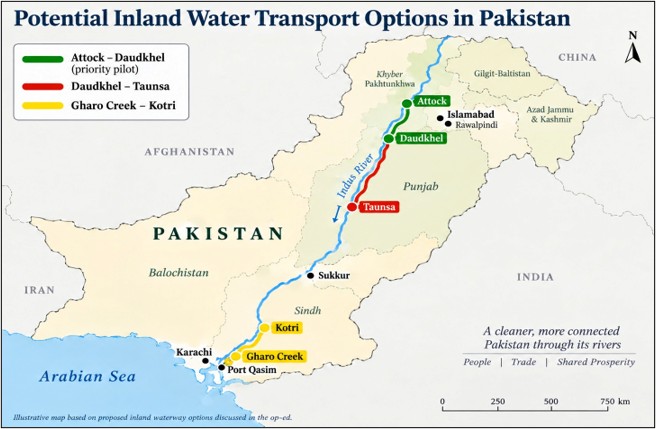
Pakistan has explored these possibilities through detailed studies and feasibility assessments. A 2017 feasibility study, later reviewed by the World Bank, found positive prospects for the approximately 170-km Attock-Daudkhel route and proposed shallow-draft barges carrying up to about 500 tons, with potential terminals at Attock, Khushalgarh, Makhad and Daudkhel. This assessment declares strong economic potential, with a 21.61% return. The reports also found that the 340-km Daudkhel-Taunsa reach is more difficult because the Indus is highly braided and unstable. The report also proposes dedicated navigation channel about 60 meters wide and 3 meters deep with 3 ports suggestions at Chashma, Bhakkar and Taunsa in Punjab. In the south, the assessment also recommended a feasible route from Port Qasim through Gharo Creek, the Kalri-Baghar feeder system and Kalri Lake to Kotri. From Kotri, the inland waterway could extend further north towards Sukkur and beyond (Fig).
The economic case for inland water transport is strongest where large and predictable cargo volumes move over long distances. The same World Bank assessment indicate freight costs of about US$0.080 per tonne-kilometre by road and US$0.064 by rail, compared with US$0.050 for a 500-DWT river-sea vessel and around US$0.023 for a 1,360-DWT inland vessel.
However, the report also indicated that transshipment, terminal handling and first and last-mile trucking can reduce this advantage. However, it assumes about US$5 per ton for each transshipment operation. Inland navigation is therefore most competitive when freight volumes are dependable, distances are sufficient and terminals are strategically located near ports, industries and logistics hubs.
Pakistan need not begin from zero. Attock-Daudkhel section already has a functioning digital navigation channel, developed as a low-cost alternative to continuous dredging. The channel provides about 5 feet of draft for barges of up to 300 tons. These barges can pass through the navigation locks at Jinnah and Chashma barrages and travel onward to Taunsa Barrage. The next practical step should be to extend this approach through a roughly 330-km digital navigation channel from Chashma to Taunsa, based on the experience already gained.
Lastly, our rivers and canals must continue to serve their primary purposes of drinking water, irrigation, hydropower, flood protection and protection of the Indus ecosystem. Any expansion of inland navigation should proceed only with strict environmental safeguards, ensuring that natural river flows, aquatic habitats and seasonal river dynamics are not compromised. With these protections in place, the operational experience from Attock-Daudkhel can provide a practical foundation for wider expansion, allowing inland waterways to become a valuable third pillar of Pakistan’s freight transport system alongside roads and railways.